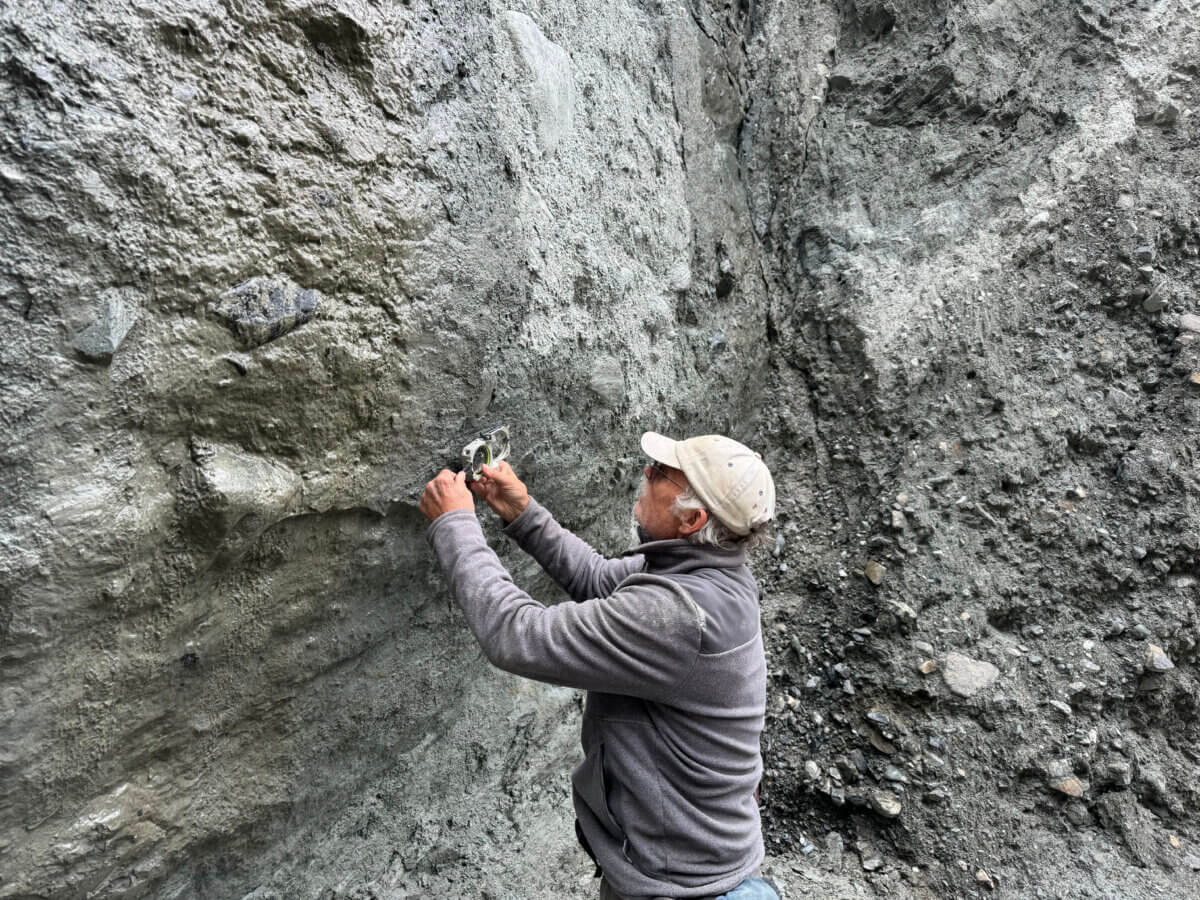
Geologist Tim Little measuring curved scratches on the Alpine Fault. (Credit: Nic Barth/UCR)
RIVERSIDE, Calif. — For the millions of people living in earthquake-prone regions, from New Zealand to California, a few minutes of warning could mean the difference between life and death. Now, by studying ancient curved scratches left behind on fault surfaces from past seismic events, scientists have discovered a way to better predict how earthquakes might travel and affect different areas.
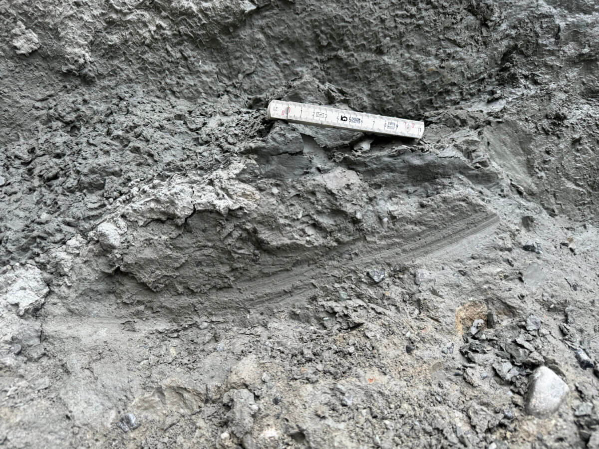
The study published in Geology introduces a new method for understanding earthquake behavior that could transform how we prepare for these natural disasters. The research focuses on curved scratches left on fault planes when massive blocks of Earth grind past each other during an earthquake. These marks, called slickenlines, work somewhat like tire marks at a crash scene, revealing the direction of movement.
“Fault planes accumulate these curved scratch marks, which until now we didn’t know to look for or how to interpret,” explains UC Riverside geologist and lead author Nic Barth in a statement.
To understand how these ancient marks could help save lives, the research team turned to New Zealand’s Alpine Fault — a massive 850-kilometer-long fracture in the Earth’s crust that handles up to 80% of the movement between the Pacific and Australian tectonic plates in New Zealand’s South Island. This fault isn’t just any geological feature, it’s a ticking time bomb with a 75% chance of rupturing in the next 50 years. What makes it particularly interesting to scientists is its clockwork-like regularity, producing major earthquakes approximately every 250 years.
The researchers focused their investigation on a fascinating section of the Alpine Fault known as an “earthquake gate.” This region can either stop earthquakes in their tracks or allow them to continue their journey, a decision that has enormous consequences. When earthquakes push through this gate, they transform from magnitude 7.5 events into far more powerful magnitude 8.0 earthquakes, dramatically increasing their potential for destruction.
The implications of this research reach far beyond New Zealand’s shores. “The scratches indicate the direction and origin of a past earthquake, potentially giving us clues about where a futur quake might start and where it will go. This is key for California, where anticipating the direction of a quake on faults like San Andreas or San Jacinto could mean a more accurate forecast of its impact,” Barth notes.
Understanding the direction of earthquake movement isn’t just academic curiosity, it could provide crucial extra minutes of warning time for vulnerable populations. Consider Los Angeles: if a major earthquake begins near the Salton Sea and moves northward along the San Andreas fault, it would direct intense energy toward the city. However, this scenario could also give residents about a minute’s warning through cellular alert systems – precious time that could allow people to ke cover, stop medical procedures, or shut down critical systems.
The study revealed two crucial findings about the Alpine Fault: the massive earthquake that struck in 1717 traveled from south to north, a direction that models show produces more intense shaking in populated areas. Perhaps more importantly, they discovered that major earthquakes can start from either end of the fault, a capability that wasn’t known before.
These insights have inspired researchers to begin looking for similar curved marks on other major fault systems worldwide. “We can now take the techniques and expertise we have developed on the Alpine Fault to examine faults in the rest of the world. Because there is a high probability of a large earthquake occurring in Southern California in the near-term, looking for these curved marks on the San Andreas fault is an obvious goal,” Barth explains.
Like nature’s own geological record, these curved lines tell stories of ancient earthquakes, helping us prepare for future ones. As Barth emphasizes, “There is no doubt that this new knowledge will enhance our understanding and modeling of earthquake behavior in California and globally.” While we can’t prevent earthquakes, understanding their patterns – including how and where they propagate – brings us closer to developing more effective early warning systems and improving earthquake preparedness.
Paper Summary
Methodology Explained
The researchers used a careful excavation process at three sites along New Zealand’s Alpine Fault. They first documented naturally exposed fault surfaces and their existing slickenline patterns, recording details like structural attitudes and track lengths. Then, using hand tools ranging from shovels to delicate instruments, they further exposed fault surfaces while taking extreme care not to create artificial marks. They used innovative techniques like pouring water from plastic bags to clean surfaces without damaging them. All observations were documented through detailed field sketches and photographs for later analysis.
Results Breakdown
The team made 233 slickenline measurements on 146 individual tracks, with 30 (21%) showing curvature. The curved tracks ranged from 10 centimeters to over 3.5 meters in length, with an average pitch deflection of about 15 degrees. At both Hokuri Creek and Martyr River, they found evidence of earthquakes traveling in both directions, while no curved slickenlines were observed at Chasm Creek. The most recent event (1717 CE) appears to have traveled from southwest to northeast.
Limitations
The study faced several constraints. Dating the slickenlines directly wasn’t possible, making it challenging to link specific marks to known historical earthquakes. Additionally, even the longest observed slickenlines only recorded less than half of the expected earthquake slip distance. The remote locations of the study sites and the need for careful manual excavation also limited the amount of fault surface that could be examined.
Discussion and Takeaways
The study introduces curved slickenlines as a valuable new tool for understanding prehistoric earthquakes globally. The findings suggest that the Alpine Fault’s earthquake gate can allow ruptures to pass through in both directions, challenging previous assumptions about fault behavior. This has important implications for earthquake hazard assessment and emergency planning in New Zealand, particularly for population centers that might experience different levels of shaking depending on rupture direction.
Funding and Disclosures
The research was supported by the Marsden Fund Council from New Zealand Government funding, managed by Royal Society Te Apārangi. Fieldwork was authorized by the New Zealand Department of Conservation. The study appears to have no conflicts of interest to disclose.


