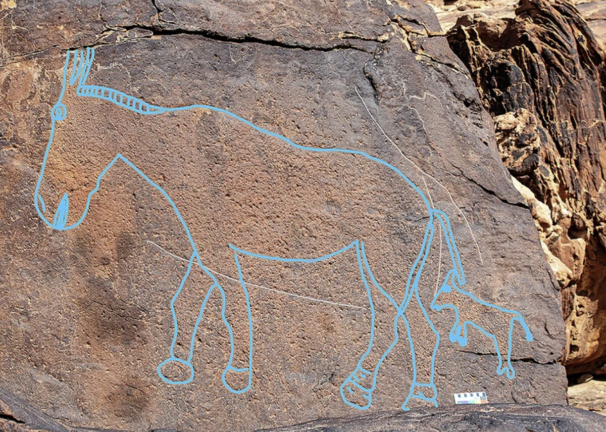
Art depicts a horse-like animal with its young, both drawn in the later cartoon style. (Photo credit: Guagnin, Shipton et al / Nature Communications)
In A Nutshell
- Giant camel carvings in Saudi Arabia: Archaeologists documented 62 panels with 176 engravings, mostly life-sized camels, etched up to 39 meters (128 feet) high on cliff faces.
- Carved during a harsh climate: Dating shows they were created 12,800–11,400 years ago, when only temporary, unpredictable lakes appeared after the Last Glacial Maximum.
- Possible desert wayfinding: Their placement near seasonal water sources suggests they may have helped travelers navigate routes between ephemeral lakes, though this remains speculative.
- Long-distance cultural links: Stone tools, pigments, and beads show connections with Levantine communities hundreds of miles away, indicating regular cross-desert travel.
- Symbolism and survival: Whether as landmarks, territorial markers, or spiritual art, the monumental carvings highlight human ingenuity and adaptability in one of Earth’s harshest environments.
JENA, Germany — Massive camel carvings etched into cliff faces across the Arabian desert weren’t just art left behind by our ancestors. New research suggests they may have served as landmarks to help ancient travelers navigate between life-saving water sources during one of history’s harshest climate periods.
Archaeological discoveries in northern Saudi Arabia reveal how hunter-gatherer communities created elaborate rock art panels featuring life-sized engravings of camels and other desert animals around 12,000 years ago. The strategic placement of these monuments near ephemeral water sources raises intriguing possibilities about their role in desert survival, though researchers emphasize the connection remains highly speculative.
Scientists working in the Sahout region have documented 62 rock art panels containing 176 individual engravings, with many carved on nearly inaccessible cliff faces up to 39 meters (128 feet) above ground. The timing and location of these carvings coincide with the first appearance of temporary lakes in the region following the Last Glacial Maximum.
“Depictions of wild animals and the marking of natural landscapes may have been a mechanism to mark routes and perhaps also served as territorial markers documenting access rights via impressive images,” researchers explain in their study published in Nature Communications.
Strategic Placement Near Unpredictable Water Sources
Rock art panels occupy prominent positions that overlook natural travel corridors and cluster near ancient lake beds where water would have collected temporarily after rare rainfall. At Jebel Misma, all engravings flank the edge of a former lake bed. At Jebel Arnaan, life-sized animal carvings follow a natural gully where water still pools briefly today after infrequent rains.
Many panels required extraordinary effort to create. One massive panel stretching 23 meters (75 feet) across two cliff surfaces sits at heights of 34 to 39 meters (111 to 128 feet) above ground, requiring artists to work on ledges only 30 to 50 centimeters (12 to 20 inches) wide. Today the sandstone is too degraded to reach the ledge safely.
“The friable nature of the substrate and the slope of the narrow ledges suggest the engravers likely risked their lives to create this art,” the research team notes.
The commitment to placing artwork in such precarious yet visible locations shows their potential importance beyond mere decoration. These monumental carvings would have been highly visible when freshly carved against the dark rock varnish coating the sandstone surfaces.
Temporary Lakes in an Arid Landscape
Understanding why elaborate wayfinding might have been necessary requires examining the environmental context. Between 16,000 and 13,000 years ago, as Earth emerged from the Last Glacial Maximum’s extreme aridity, ephemeral water bodies called playas began forming across the Nefud desert for the first time in millennia.
Unlike permanent oases, these water sources appeared and disappeared unpredictably with irregular rainfall patterns. The lakes remained temporary and seasonal throughout this period, never developing into reliable permanent water sources. Success in this environment required detailed knowledge of multiple ephemeral lake locations, optimal travel routes between them, and timing of their unpredictable availability.
Archaeological excavations beneath the panels revealed occupation layers dating between 12,800 and 11,400 years ago, confirming human presence during the crucial period when these temporary water sources first became available. Stone tools, hearths, and other artifacts show intensive use of areas near the rock art, supporting the hypothesis that these locations served as important gathering points.
The animals depicted in the carvings reinforce their potential connection to seasonal patterns. Male camels are shown with bulging necklines indicating rutting season, which coincides with winter rainfall when ephemeral water sources would be most likely to appear. Many animals appear to display thick winter fur, further linking the imagery to specific seasonal conditions.
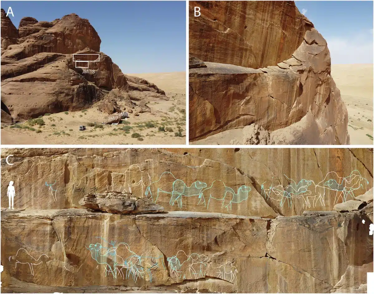
A: The main rock art panel sits high on a cliff, 34 to 39 meters (111–128 feet) above the ground. Excavation trenches (JMI7 and JMI8) were dug directly below the carvings — the project vehicle in the photo gives a sense of scale.
B: From above, you can see the narrow, downward-sloping ledges that ancient artists had to stand on to reach the panel, showing how risky the work was.
C: A 3D model highlights 19 life-sized camels and 3 wild equids carved into the cliff. The white outlines show earlier, highly realistic engravings, while the blue outlines show later, more stylized versions. A figure of a person (1.7 m tall) was added for scale. (Photo credit: Guagnin, Shipton et al / Nature Communications)
Long-Distance Connections Across the Desert
Stone tool analysis reveals these Arabian communities used identical technology to groups in the Levant, hundreds of miles away across challenging desert terrain. El Khiam arrowheads characteristic of early farming communities in modern-day Israel and Palestine were found in dated archaeological layers at the rock art sites.
Marine shell beads discovered during excavations came from either the Mediterranean Sea or Red Sea – the latter being over 320 kilometers (200 miles) away. Green pigment crayons and specialized grinding stones match materials found at contemporary sites across the Fertile Crescent, indicating regular long-distance travel and trade despite the harsh intervening terrain.
“The artefact assemblages include Levantine stone tool types and decorative forms of material culture, suggesting regular and repeated cultural contact across long distances,” the study notes.
If the rock art did serve a wayfinding function, it likely marked not just local routes but major pathways connecting Arabia to distant regions. As water availability improved, these routes may have facilitated the spread of early farming technologies and cultural innovations across vast distances.
Artistic Evolution Over Millennia
The carvings show four distinct phases of creation spanning potentially thousands of years. Earlier phases feature small, stylized human figures, followed by large naturalistic animal depictions where individual engravings show unique characteristics and detailed features. Later phases become more standardized, with “cartoonish features” and “near-identical depictions of animals” that follow a more uniform artistic style.
This evolution might reflect changing functions over time, from highly detailed representations possibly encoding specific information to more symbolic markers serving broader cultural purposes.
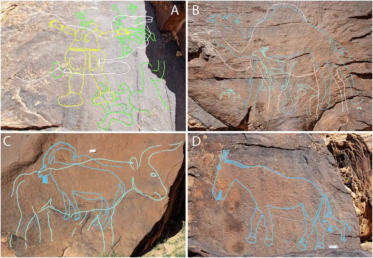
Camels dominate the engravings at 72%, followed by ibex at 12%, wild horses at 10%, and gazelles at 5% – all species well-adapted to arid conditions. A single depiction of an aurochs (wild cattle) stands out as unusual, since these animals required regular water access and might have indicated particularly reliable ephemeral water sources.
Creating these monuments required remarkable skills and planning. Many panels were carved using direct percussion with specialized pecking stones made of ferruginous sandstone, requiring artists to work at arm’s length while preventing them from seeing complete images. Discovery of these wedge-shaped pecking tools made from tough ferruginous sandstone in archaeological layers directly beneath rock art panels provides the strongest evidence linking the artwork to the dated occupation.
However, researchers acknowledge this connection relies on what they term a “parsimonious assumption” – that the pecking stones were used to create the art above them rather than being transported from other rock art locations. While this interpretation is reasonable, it remains indirect evidence rather than definitive proof.
Uncertain but Intriguing Possibilities
The evidence for wayfinding functions remains speculative, and researchers emphasize multiple alternative explanations. The rock art could equally have served purely symbolic, territorial, or religious purposes unrelated to navigation. The monumental scale and prominent placement might reflect spiritual significance, territorial claims, or artistic expression rather than practical wayfinding needs.
What remains clear is that these communities successfully adapted to one of the world’s most challenging environments during a period of dramatic climate change. Their monumental artwork, whether serving practical or symbolic functions, required sophisticated planning, specialized tools, and willingness to take extraordinary risks.
The artwork also demonstrates that these weren’t isolated desert wanderers but part of broader cultural networks spanning hundreds of miles. The presence of marine shells from over 320 kilometers away, specialized pigments, and shared tool technologies indicates regular contact with distant communities despite the harsh intervening terrain.
Analysis of rock varnish – the dark coating that forms on exposed stone surfaces – confirms the antiquity of the oldest panels. Complete re-varnishing of engraved lines requires around 8,000 years, indicating this artistic tradition has persisted for most of human history in the region.
Whether these magnificent carvings served as landmarks for travelers, territorial markers, spiritual sites, or purely artistic expression, they represent a remarkable achievement by communities who found ways to thrive in one of Earth’s most demanding environments. Their success during the transition from Ice Age to modern climate conditions offers insights into human adaptability and innovation during periods of environmental uncertainty.
Paper Summary
Methodology
Researchers conducted archaeological surveys and excavations at three rock art sites (Jebel Arnaan, Jebel Mleiha, and Jebel Misma) in the Sahout region of northern Saudi Arabia. They excavated four trenches that revealed stratified archaeological deposits and documented 62 rock art panels containing 176 engravings. Dating was accomplished through optically stimulated luminescence (OSL) techniques applied to quartz sediments and radiocarbon dating of charcoal from hearths. Environmental context was established through excavation and analysis of ancient lake (playa) deposits. The study involved systematic documentation of rock art using high-resolution photography and 3D modeling, plus detailed analysis of over 1,200 stone tools and other artifacts.
Results
The research revealed human occupation between 12,800 and 11,400 years ago, with the earliest evidence of surface water in the region appearing between 16,000 and 13,000 years ago following the Last Glacial Maximum. Rock art includes 130 life-sized naturalistic engravings of desert animals, primarily camels, created using pecking techniques. Archaeological deposits contained stone tools matching Levantine Pre-Pottery Neolithic types, including El Khiam and Helwan points, plus grinding stones, marine shell beads, and pigments indicating long-distance trade connections. Environmental analysis confirmed seasonal water availability in temporary lakes within an overall arid climate.
Limitations
The study was limited to three sites in one region, potentially representing only local conditions. Direct dating of rock art remains challenging, relying on associated archaeological deposits and rock varnish analysis rather than direct techniques. Some engraving tools could theoretically have been transported from other locations, though this is considered unlikely. The research covers a relatively short time period and may not capture longer-term climate and cultural variations. Environmental reconstructions are based on limited sediment cores from two playa locations.
Funding and Disclosures
Research was funded by the Saudi Heritage Commission, a British Academy/Leverhulme Small Research Grant, King Abdullah University of Science and Technology (KAUST), the Research Council of Norway through the SFF Centre for Early Sapiens Behaviour, and King Saud University Researchers Supporting Project. The authors declare no competing interests. Permission for excavations, sampling, and analysis was granted by the Heritage Commission of Saudi Arabia’s Ministry of Culture.
Publication Information
Guagnin, M., Shipton, C., Al-Jibreen, F. et al. “Monumental rock art illustrates that humans thrived in the Arabian Desert during the Pleistocene-Holocene transition.” Nature Communications 16, 8249 (2025). Published online September 30, 2025. DOI: 10.1038/s41467-025-63417-y


