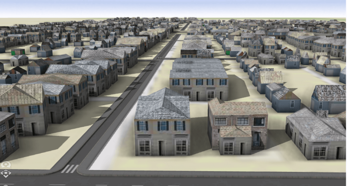
3D model of the Driving Park neighborhood in Columbus in 1961 Image: Center for Urban and Regional Analysis/Ohio State University
COLUMBUS, Ohio — Artificial intelligence may soon allow people to virtually explore their hometowns as they appeared 50, 100, or even 150 years ago. Researchers at The Ohio State University have devised an innovative method for creating 3D digital models of historical neighborhoods, employing machine learning techniques and old maps. Beyond providing a fascinating glimpse into the past, these digital models will enable researchers to conduct studies that were previously challenging, such as estimating the economic losses associated with demolishing some of these streets.
This study utilized Sanborn Fire Insurance maps, which were developed to aid fire insurance companies in assessing their liabilities in approximately 12,000 U.S. cities and towns during the 19th and 20th centuries.
“The story here is we now have the ability to unlock the wealth of data that is embedded in these Sanborn fire atlases. It enables a whole new approach to urban historical research that we could never have imagined before machine learning. It is a game changer,” says Professor Harvey Miller, a co-author of the study from Ohio State, in a university release.
The major challenge for researchers had been the laborious and time-consuming process of manually gathering usable data from these maps, a problem that was addressed with their digitization. One of the team members developed machine learning tools — a branch of AI — capable of extracting specific details about individual buildings from the maps. These details included their locations, footprints, the number of floors, the construction materials used, and their primary purpose, such as residential or commercial use.

The researchers validated their machine learning techniques using two neighboring areas on the near east side of Columbus, Ohio, which were largely demolished in the 1960s. The analysis of the two neighborhoods, using 13 Sanborn maps produced in 1961, resulted in digital models developed through machine learning techniques.
Their analysis reveals that a total of 380 buildings, including 286 houses, 86 garages, five apartments, and three stores, were demolished in the two neighborhoods to make way for a new highway. The accuracy of the machine learning model was high, yielding about 90% accuracy for building footprints and construction materials.
“The accuracy was impressive. We can actually visualize these neighborhoods in a way that was previously impossible. Our aim is to reach a point where we can offer people virtual reality headsets and allow them to stroll down a street as it appeared in 1960, 1940, or perhaps even 1881,” says Prof. Miller.
Miller adds that these machine learning techniques could potentially enable researchers to create similar 3D models for nearly any of the 12,000 cities and towns represented in the Sanborn maps. This could facilitate the reconstruction of neighborhoods lost to natural disasters, urban renewal, depopulation, and other types of changes.
“There are numerous potential research applications. This will be an invaluable resource for urban historians and various other researchers. The creation of these 3D digital models and the reconstruction of buildings offer a wealth of insights beyond what traditional maps, charts, or graphs could provide. The potential here is truly incredible,” concludes Prof. Miller.
The study is published in the journal PLoS ONE.
South West News Service writer Stephen Beech contributed to this report.


